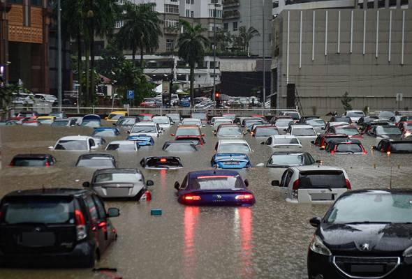
Published in Astro Awani, Focus Malaysia, The Malaysian Insight, the sundaily, New Straits Times, and Asia News Today, image by Astro Awani.
Frequent flash floods in the Klang Valley (i.e., Kuala Lumpur/KL, Putrajaya and Selangor) have become more distressing, particularly for residents who stay in low-lying areas or those commuting by car and park in the office basement area. As there is often little time to move the personal and household assets to higher grounds, the flooding also damages the furniture and electrical appliances not to mention the fixtures such as flooring, costing tremendous losses.
Last year, the Klang Valley experienced the worst flooding after a two-day continuous heavy rainfall between December 17 and 18, which was followed by two (minor) floods on March 7 and April 25.
The statement from the Malaysian Meteorological Department (MetMalaysia) in relation to the south-west monsoon from May 14 until mid-September indicates that the Klang Valley, as part of the west coast Peninsula, might experience frequent heavy rain with strong winds and lightning during the next few months.
Besides the Klang Valley, the west coast of the Peninsula also consists of Perlis, Kedah, Penang, Perak, Negeri Sembilan, Malacca and Johor – states that are becoming more vulnerable to extreme weather phenomenon resulting in heavy flooding in this case.
Will KL become a flood city like Jakarta in the next few decades?
Weather patterns nowadays are getting more unpredictable due to the intensification of climate change. Apparently, the current administration and Kuala Lumpur City Hall (DBKL) have only recently become more pro-active in flood management and mitigation measures – without which the capital city could experience even worse flooding to the point of “submerging underwater”.
The December flooding has revealed a lack of proper and effective coordination between the federal and state governments. As the National Disaster Management Agency (Nadma) did not want to lead the flood relief efforts, many people were stranded on the roads and rooftops for days. There were also unanswered screams of help from flood victims, as well as the reports of bed-ridden elderlies partly submerged in floodwater.
For now, DBKL is committed to tackling the flash floods issue in the city centre by introducing 14 interim measures at approximately RM10 million under the Flash Flood Mitigation Action Plan 2022. However, the Public Works Institute of Malaysia (Ikram) requires one year to study the root causes of frequent flash floods and drainage systems. This raises the question mark as to whether KL is set to brace for more flooding in the next six months.
According to the study conducted by the Centre for Governance and Political Studies (Cent-GPS) in 2019, Kuala Selangor could disappear by 2030 and the Kuala Lumpur International Airport (KLIA) might just be located next to a beach due to erosion of coastal lines.
The digital stimulation developed by Cent-GPS through the Shuttle Radar Topography Mission (SRTM) model is worrying enough. Many countries have witnessed rising sea levels in recent years.
The Intergovernmental Panel on Climate Change (IPCC) forecasted that sea levels could be at least 1.1 metres higher by the end of this century. At the same time, severe flooding events will happen regularly in low-lying cities.
In addition, the C40 network of global cities addressing climate change warned that more than 800 million people living in 570 cities worldwide would be vulnerable to the rising sea levels by 2050 due to the faster melting of polar ice caps than anticipated.
The melting ice phenomenon has been shown in a study based on NASA and ESA satellite data whereby the Arctic Sea ice was about 1.5 feet (0.5 meters) thinner in 2021 than in 2019. Despite KL being around 7,060 km away from the Arctic Circle, our capital city would face a substantial rise in sea levels within the next few years if carbon emissions remain at business-as-usual levels.
Over the past two decades, Malaysia’s annual carbon dioxide (CO2) emissions have increased from 126.20 million tonnes to 272.61 million tonnes, according to Our World in Data. In per capita aspect, Malaysia also recorded more CO2 emissions – from 5.44 tonnes in 2000 to 8.42 tonnes in 2020.
Compared to neighbouring ASEAN countries such as Singapore (i.e., 7.78 tonnes in 2020) and Indonesia (i.e., 2.16 tonnes in 2020), Malaysia recorded higher CO2 emissions per capita.
Therefore, now is the time for the current administration to enforce both climate and flood mitigation measures in KL, the most densely populated region in the country (i.e., 8,157/km2) as shown under the DOSM’s Population and Housing Census of Malaysia 2020.
Proactive approach from the Malaysian government would avoid KL becoming the next Jakarta.
Meanwhile, as of January this year, the Indonesian government had started relocating its capital city to Nusantara.
The following are the policy initiatives that EMIR Research would like to recommend the current administration and DBKL to implement for KL:
- Create more mini-forests along together with the installation of pedestrian walkways or cycling pathways to remove carbon dioxide and serve as a noise buffer. Although mini-forests are small, they could provide habitat for other organisms like birds and insects. At the same time, mini-forests could restore biodiversity to the city.
Permeable, highly-porous materials could be used to construct pedestrian walkways or cycling pathways. The water would seep through the surface and become groundwater or drain into drainage systems.
- Utilise idle land and abandoned buildings to grow various kinds of food crops, which is made possible by rapid development in agritech such as hydroponic, and indoor and vertical farming. Converting empty spaces into farms would encourage local food production and reduce greenhouse gas emissions.
One Utama Rooftop Farm is a good example, whereby the owner utilised the rooftop of the shopping mall to integrate agriculture and aquaponics together, enabling city dwellers to purchase vegetables or fishes that are pesticide-free.
Alternatively, some farmers could consider (re)locating their agricultural sites to rivers and lakes and even coastal areas to create floating farms. Thus, farmers could compact and layer the plants to become rafts about 1 metre deep and plant the seeds inside the them. The purpose of these rafts is to allow the agricultural farms to float on top of the floodwater.
- Increasing car-free zones with more public transport service frequency would encourage the citizens to shift their mindset by reducing the usage of privately owned vehicles. Prioritising walking, cycling, shared vehicles and public transportation would reduce carbon footprint in highly urbanised areas.
- Introduce reforestation around low-lying, flood-prone areas to regulate water flows, act as barriers against storm surges and protect against erosion and mudslides.
- Clear solid pollutants that clog drains and rivers on a weekly basis. The government could install simple, custom-designed surveillance Internet of Things (IoT) modules at designated spots along the river to keep track of the clearance progress. The IoT package can consist of a pollution detection sensor, a camera, a micro-controller, a transmitter and a rechargeable lithium-ion battery.
- Increase the carrying capacity of rivers and drains – either widening, deepening or both.
- Construct swales along major highways, roads and housing areas prone to flooding. Swales are shallow, broad and vegetated channels that could convey stormwater and treat run-off to reduce pollutants. Thus, the water does not collect on land and reduces the likelihood of flooding events.
- Create regular awareness campaigns and education programmes to promote understanding of environmental issues, especially disasters.
- Continue developing effective early warning systems and disaster risk-reduction plans. For instance, MetMalaysia and Nadma could apply Geographic Information System (GIS) to produce a flood hazard map daily, identifying high flood risk areas.
Also, Nadma and the National Security Council (NSC) could warn the public through Short Message Service (SMS). Residents who stay in low-lying areas could put their belongings in waterproof containers and relocate electrical appliances to higher ground in advance.
Moving forward, the current administration should form a Climate Change Commission suggested by the All-Party Parliamentary Group Malaysia (APPGM) – Sustainable Development Goals (SDG) in January – comprising local and international experts to provide policy recommendations on climate change matters, including adaptation and disaster risk management in the country.
Meanwhile, all Malaysians must do their part in taking care of the environment by not dumping any rubbish into the drain and river, for example. The behavioural change among citizens would prevent further clogging of drains and rivers, reducing the risk of intense flooding, particularly in the city centre of KL, which has the potential of becoming a flooding city.
Amanda Yeo is Research Analyst at EMIR Research, an independent think tank focused on strategic policy recommendations based on rigorous research.

